Tag: hiking

Psyching Ourselves Up

Let me start with the fact that climbing Mt. Kilimanjaro, Africa’s highest peak at 19,340 feet, was the hardest physical thing we have ever done in our lives. Ted and I do a fair bit of hiking in Colorado, including several 14ers (14,000+ foot peaks) the past few summers. We even did a 15er in Peru on our hike to Machu Picchu. However, Kili is a 19er and that extra 4000 ft in altitude makes all the difference in the world.

Gonna bag that peak

Many people prepare for weeks/months/their lives for this particular undertaking. However, we had spent the last few days lying on the beach (at sea level, obviously) in Zanzibar drinking cocktails. Prior to that we had been on and off safari for the previous 2 months which includes ridiculous amounts of eating and hours upon hours of sitting in a jeep. What I’m getting at here is that we were not in the best hiking shape of our lives, yet we were about to take on our biggest physical challenge to date.

Before our climb, Ted reached out to a few friends that had climbed Kili to ask them about the hike and to hear their experiences. He got a few intimidating responses ranging from miserable altitude headaches to incredibly grueling hard work. After hearing these reviews, he decided that there was no good reason to share this information with me until after the climb, and to this day I thank him for that.

With ignorant bliss, I thoroughly enjoyed seeing the mountain for the first time on the drive from Kilimanjaro airport to Moshi, the access town. Glowing in the evening sunset, Africa’s biggest peak dominates the skyline, literally popping out of nowhere. It is nothing less than breathtaking.

Kilimanjaro at sunset

We got our hotel just as it got dark. We carbo-loaded on some pasta for dinner, repacked our bags for 6 days and 5 nights of mountain climbing, and did our best to get some sleep before the big trip.


Table Mountain Trials and Tribulations

We arrived in Cape Town at the tail end of an extreme heat wave. Temperatures were at or near 100 degrees and the whole city was moaning and groaning in discomfort. Though the thermometer had dropped a few degrees, it was on a still very hot day that our fit and ambitious group attempted to climb Cape Town’s famous and beautiful Table Mountain.

Our host at the Lodge had tried to deter us and told us that we needed to leave early in the morning to avoid the direct sunshine on the path, but we merely smiled and nodded as we continued to enjoy our leisurely breakfast.

Upon reaching the trailhead, we were greeted with some rather steep stairs and very minimal shade. Within 90 seconds I was pretty sure that it was going to be too hot and/or difficult for our group to make it to the top however, I kept my mouth shut and we pressed on.

Nearly 1 hour into what is supposed to be a 2-3 hour hike, the group had a pow-wow to discuss our options. My mother, who is in great shape, was extremely uncomfortable in the heat and wanted to head down to the take the cable car up instead. I offered to go with her. My Dad, was determined to press on to the top, as was Ted.

View from the trailhead - a long way to go!

Mid-way up, getting real hot...

Looking back as we near the top

After nearly losing my mother to heat exhaustion (I swear the woman doesn’t sweat), we made it safely to the bottom where we promptly consumed one Powerade and one bottle of water each (as we’d sent most of our water on with the men). Once I was sure that neither of us were going faint, we bought our tickets for the cable car and ascended the mountain like 99% of the tourists do.

Once we got to the top, it had been over 3 hours and I was almost expecting that Ted and Lar would be up there waiting for us. When we arrived and there was no sign of them, I decided to go looking. I plopped Sal (who was quite worried at this point) at our planned meeting-up spot, bought a couple of liters of water and went running down to trail to rescue my husband and father.

But no rescue was needed. I didn’t get more than 200 yards before running into to them. They were tired and had run out of water so were thrilled to see I had some (though Ted had been wishing for it about 30 minutes earlier). However, they were there in one piece and were happy to have successfully made it to the top.

After a group refueling, we finally got around to taking in the amazing panorama. The view of the city and the surrounding beaches from the top is different in every direction. We had a blue-sky clear day and we could see for miles.

Northward views from the top!

Southward views from the top!

Graces on top!

The rest of the day was rightfully spent napping and relaxing before heading out for a much deserved celebratory dinner!


Picture of the Week

Southern Patagonia has been a wonder of nature.  Here’s a nice shot of Cerro Torre peak, from the trails near El Chalten, Argentina.  Go there.

Cerro Torre


The Super Trek

When our brief stint of luxury was over, we headed back to El Calafate and then back to the bus station in time to catch the afternoon bus to El Chalten. Wonderfully, our new friends, Bern, Dave and Jesse were on the same bus.

El Chalten is a hiking and climbing mecca. The famous Fitz Roy range (the range the Patagonia clothing logo is designed after) towers over the quaint town of Chalten. The little town’s population soars during the summer season as people come from all over the world to check this place out. Though El Calafate is a proper tourist town with all the restaurants and souvenir shops to prove it, El Chalten feels more like a frontier town with many of the roads still unpaved.
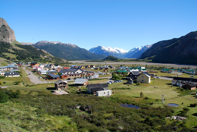
El Chalten

The hiking around town is extraordinary and you can literally walk from anywhere in town to the trailheads. There are two very popular hikes that people do and we all planned to do one the first day and one the second day, depending on the weather. The weather in all of Patagonia is notoriously unstable. We had been warned about rain, clouds, cold temperatures and wind being the norm and sunshine being an exception to the rule. We had lucked out in Torres del Paine, we had lucked out visiting the Perito Merino glacier earlier in the week, and we once again lucked out in El Chalten.

As the five of us headed out on what was meant to be a 6 hour (roundtrip) hike to Laguna Torre with a view of the majestic Cerro Torre peak, we couldn’t have asked for a more beautiful day. Even the ever-present wind was taking the day off. We were very appreciative of our luck and had a great hike to the view of Cerro Torre where we had lunch. On the way down, we got to talking and the group decided to take advantage of the amazing weather and press on towards the second popular hiking destination. The clouds can be so thick that they completely obstruct the view, so we decided to keep walking on the blue sky day.

Hiking to Cerro Torre
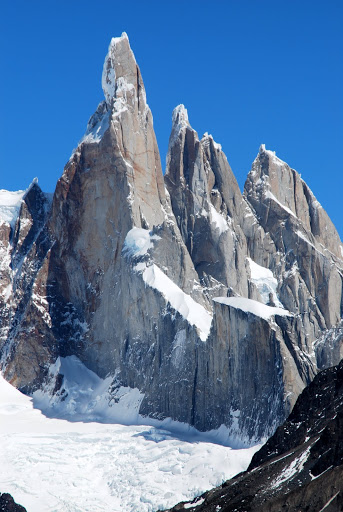
Cerro Torre, up close

Our hiking crew at Laguna Torre

The path we were on conveniently connected over to the other path and rewarded us with spectacular views of the Fitz Roy mountain range and a crystal-clear blue lakes along the way.
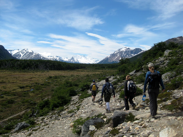
Hiking in the park
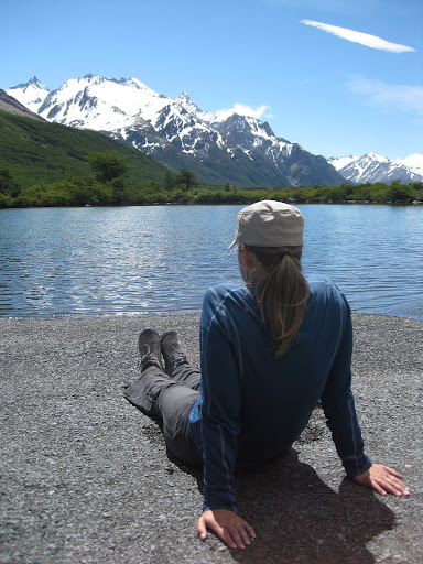
Rest stop

At another junction, the boys decided to head all the way up to Laguna de los Tres – the high view point for Fitz Roy. At the thought of an additional 3.5 hours of hiking on top of what we had already done, Jesse and I decided to head down.

We got back to town around 6:00 pm after a 10-hour, 16+ mile day of hiking, feeling pretty good about ourselves. We both got cleaned up and met for beers at the local brewery to wait for the guys. Little did we know that they wouldn’t roll in until just after 10 pm and 25+ miles of hiking! Luckily it stays light until after 10pm in Patagonia at that time of year because I wouldn’t have felt okay about them wandering in the dark. Jesse and I had just started to get worried when they arrived at the brewpub famished and exhausted.

Bern, Dave, and Ted

Laguna de Los Tres (covered with ice and snow)

The beginning of a LONG way down

We later learned that the full hike the guys did is known as the Super Trek. Needless to say the next day was a sleep-in and relaxation day.

For our last night in the area we decided to cook a big dinner at the hostel and drink some wine with all the fun new people we had met. As the night went on, we found our table growing larger and larger and before we knew it we were next door at the local tango bar! There were professionals on hand who were quite impressive, and many Argentine men who were happy to lead, and then there was our group that managed to have quite a great time with little to no tango knowledge whatsoever. It was a hilariously fun night and a great way to celebrate our last night in this amazing part of the world!
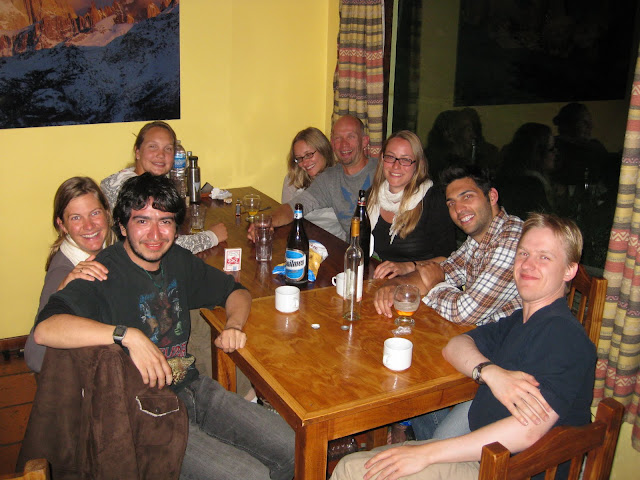
Family dinner and drinks

The Tango Party

Addendum – Our friend Dave is not a huge hiker, and the Super Trek basically broke his soul. Read his hilarious account of our day on his and Jesse’s blog.


Heading West to Chile

From Bariloche, Argentina we headed west to Puerto Varas, Chile. The Chilean border crossing was quite intense and not recommended for drug smugglers. Checking out of Argentina was pretty routine, but getting into Chile is a pain. Everyone had to get off the bus and everyone’s luggage had to be sniffed by dogs AND put through an X-ray machine. They are very strict about all the normal stuff, but ridiculously strict about any food or beverage item. Ted and I had made some sandwiches for lunch to be cost-conscious but there was no way those sandwiches were going to be allowed over the border so we had to eat them on the spot at 10:30 a.m.!

Puerto Varas was luckily worth the hassle. As Bariloche is part of the Argentine Lake District, Puerto Varas is in Chile’s Lake District. However, while Bariloche is surrounded by mountain ranges, Puerto Varas is surrounded by volcanoes. Big ones.

Osorno Volcano

For a day trip we headed out to the Vicente Perez Rosales National Park for some walking around. We met a large group of Americans on the bus ride out there who were living in the area and volunteering at schools by helping the local English teachers with their classes. They invited us to hike with them and we happily accepted. While hiking you could look to your left at a beautiful, cone-shaped, snow-covered volcano or to your right at the fjords and the lake. It’s nice to have options!

Hiking in the Park

Hiking in the Park

Hiking in the Park

On the ride back to town we stopped to see some incredibly powerful waterfalls just down the road from the National Park – the Saltos de Petrohue. Though not impressive in height, the quantity and strength of them certainly was.

Saltos de Petrohue

Saltos de Petrohue

Thanks to our good friends at Adventures Within Reach (AWR), we were able to sit down and have drinks with a local and learn a bit about both Chile and tourism in the region. We met with a wonderfully great guy named Gerardo who owns a sea kayaking and rafting company called AlSur Expeditions. AWR uses AlSur for their trips in the Lake District, so naturally we had to test them out!

Rafting the Petrohue

Rafting the Petrohue

We celebrated Ted’s birthday in Puerto Varas, starting the day on one of Gerardo’s half-day rafting trips which was a blast. The weather didn’t invite too much more outdoor activity that day, but we managed to entertain ourselves with wine and a delicious seafood dinner. We later met Gerardo out for another round of drinks and then onto another bar where we met up with the Americans that we hiked with earlier that week. Considering we didn’t know anyone in the area when we arrived a couple days earlier, Ted was properly celebrated as he rang in the big 3-1.


Industry Bloggin’

My latest contribution to the World Nomads Responsible Tourism Blog, this time about our stay at Refugio Frey in Argentina’s Lake District.  Check it out at the link below:

Argentina’s Accessible Backcountry


Frey Rhymes With Hey

Our favorite activity in the Bariloche area was a hike and overnight stay in the Frey Refugio. The trip was recommended to us by our friend Steph from Boulder who was down living in Bariloche when we were there. We were able to get together for drinks and we can’t thank her enough for the tip!

A refugio is a backcountry hut that you can only access by hiking. It offers ‘refuge’ to any hiker, climber, or skier in the area that needs a place to lay their head at night. You don’t have to have a reservation to stay, you can just show up. The refugios will also provide hot food, sleeping bags, tents, gas for cooking, and other things you might need up there (for a cost). Some people bring a tent and all their own food and only have to pay if they wish to use the refugio’s stoves for cooking. Some people bring nothing and pay for meals and supplies when the arrive.

Our hike up to the hut was fantastic. It was a cruisy 10km (6 mile) hike overlooking a lake and up through a beautiful old forest. When we got high enough, we got to walk through a bit of snow up to a mountain pass to get to our final destination. The air was quite warm but the snow still remained from the previous winter and just made the beautiful mountains look more beautiful.

Hike to Frey

Hike to Frey

Crazy Bridge

The view from Frey is pretty ridiculous. It is surrounded by a (snow-covered) lake and lots of pointy, jagged peaks. A lot of rock climbers set-up camp at this refugio because of all the amazing routes in the nearby vicinity. No rock climbing for us, just exploring the area by foot and taking in the views is quite entertaining. We also met travelers from all over, read our books, wrote postcards, enjoyed a refugio-made pizza and just relaxed.

Frey Hut

Hot Pizza at a Hut?!?!

Sunset at Frey

There are several other huts in the area and even a trail that connects 3 or 4 of them. However, the trails were closed because they were still too snow-covered to be safe. I guess we’ll have to add Bariloche’s refugio circuit to our list to do next time!

View from Frey


Colca Canyon

One of the most popular side-trips to do out of Arequipa, Peru is a hike in the Colca Canyon. Many tour operators run 2 or 3 day trips to the area and we did a bit of detective work to determine what we wanted to do and if we wanted to do it ourselves or go with a group. We opted to do it independently and decided upon a 3 day/2 night excursion.

Though we would normally take a local bus to our starting off point, a national election had made bus travel super busy as many people had to return to their home towns to vote locally. So wonderfully, Ted was able to bum us a ride to our starting point with a tour operator that was leaving on a guided trip.

After a fairly sleepy first day in a very small access town, Cabanaconde, we headed down into the canyon. Colca Canyon is advertised as being twice as deep as Arizona’s Grand Canyon and though it is certainly the case, the canyon itself is actual not nearly as grand. The canyon is beautiful but it rather than wide, it is long and skinny. As you would imagine, the first day of walking was all downhill. There are a handful of little towns at the bottom so when we reached the river around lunchtime, we were happy to be met by a young boy that was hoping we’d be customers for lunch at his home. We happily agreed and were treated to quite a delicious midday meal in a tiny little place that also provided overnight accomodation for weary hikers.

After lunch we hiked some rolling hills and just when the heat of the day and the miles of hiking were starting to tire us out, we caught a glimpse of our final destination: the Oasis. We had heard a lot about the Oasis but nothing quite prepares you for the shock of green vegetation and the sparking blue swimming pools seen from above that contrast with the brown hills and desert cactus that we’d been hiking through all day. From above, the oasis is just that. A beautiful, welcoming respite that marks the end of a long day and place to relax and cool off. I couldn’t get there fast enough!

The accomodations were basic to say the least, but we got to take a dip in a pool and were fed a big heaping plate of pasta so no one was complaining.

The hike out the next day started early to avoid the direct sunlight on the pretty demanding hike up. However, after quite a few hikes under our belt already we made it up and out of there without too much trouble. Little did we know that it would be the bumpy, long bus ride back to Arequipa that would prove to be an equally challenging experience for our sore muscles!


Hiking Fools

We’ve managed to get in quite a few amazing hikes so far on our trip. They can conveniently be divided into two different types – hikes that require a machete and rubber boots (aka hiking in a cloud forest), and hikes that do not require a machete and rubber boots (aka hiking along the rims of volcanic crater lakes).

Our cloud forest hikes occured while we were living with a family and going to Spanish school in Pucara. The family lived in a beautiful area surrounded by a dramatic landscape of steep cliffs and flat mesas. They were also blessed with spectacular cloud forests (where they hadn’t already been chopped down or burned for farming).

Our friend Peter took us on our first hike down the side of one of the cliffs to the river on the valley floor. He also arranged for us to go on our second hike with a guide named Milton (seen to the right here) who is intimately involved in protecting and reforesting a nearby cloud forest reserve. Milton was a great guide and you could tell that he was passionate about his work with the preserve. After our first two hikes, I was under the impression that all hikes were led by guides wearing knee-high rubber boots and carrying machetes, as both Peter and Milton sported that uniform. It is quite entertaining to hike behind machete-wielding trailblazers, but much needed as the cloud forests are quite dense and the plants grow quickly covering the trails.

Our third hike was lead by Peter’s friend and best guide, Jose (seen left here).  Jose was with us for 3 days as we visited different communities so we had a chance to get to know him well and also to learn that his English is better than he’d led us to believe!

Jose took us on a spectacular hike around Lake Cuicocha. It was a lake that formed after the Cotacachi Volcano exploded 3100 years ago. Though it’s not a particularly big lake (only 2 miles across), it’s extremely deep – nearly 650 ft. Because of it’s high sulfur content and the continued volcanic activity below, there is little to no life in the lake. We hiked around the nearly the whole thing (~7 miles) and had the place almost to ourselves – only passing one other group along the way. Jose teased us that only foreigners like to walk around the whole thing so that probably explains it!

Our second crater lake walk was around Lake Quilotoa at the top of the Quilotoa Volcano. The locals claim that this lake is bottomless (though geologists say that it is actually about 900 feet deep). We hired a truck with 3 other Americans that we met while staying at the Black Sheep Inn. The five of us and a guide rode in the back of the truck for an hour up to the top of the volcano. We were quite high in elevation at that point (12,800+ ft.) and it was extremely cold and windy up there – but the incredible view was well worth it. We then walked around a ¼ of the lake before descending down the edge and walking back to the Inn through beautiful Andean scenery and small towns.


Copyright © 1996-2010 Oh, the Places We'll Go. All rights reserved.
iDream theme by Templates Next | Powered by WordPress