Tag: Mountains

Leaving on a Jet Plane – NOT

After a couple days of downhill walking, beautiful and arid landscapes, and splurging on new and exciting foods that we hadn’t seen along the trail, our time on the Annapurna Circuit came to an end. The village of Jomson is the main hub in the area and it is from here that you organize your transport back to civilization. The options include a $90 flight in a small plane that flies over Annapurna’s tallest peaks and gets you back to Pokhara in about 25 minutes. Or an assortment of 4 different buses and Jeep rides, taking 10+ hours, spread over 2 days that costs closer to $15. Please remember that the ‘roads’ are miserable – nearly all dirt, pot-holed, narrow, at times dangerous – and the transportation is uncomfortable at best.

The hike down to Jomsom

Very different, but equally stunning landscapes on this side of Thorong La Pass

Tiered irrgation in the desert

Vegetables on our pasta - what a novel concept!

For some reason, the guesthouse had an Ohio State t-shirt up. Charles was non-too-pleased

Seems like a pretty easy choice, huh? Unfortunately, when your traveling for a year dropping $180 for a 20-minute activity does not fit in the budget. And so it happened that our friends visiting from the States who were time-short and money-long opted for the plane flight while we and our fellow round-the-world trippers made the trip overland. As a reward for our misery, the village we stopped at overnight had hot springs that we happily soaked in and wicked views of an incredibly unreal peak.

Setting off on our bus journey

We wave goodbye to the flyers, and their new friend

Our bus ride back was rather spacious

Jealous

But we got to do this

And see this!

So take that Charles and Kate! Or rather, we just wish you would have taken us with you.


Thorong La Pass

Our days and days of hiking along the Annapurna Circuit were inching us toward the big pass we had to get over. At 17769 feet (5416m), it’s definitely up there and the highest elevation most of our group members had ever climbed. We spent two nights in the village of Manang shortly before the pass to allow our bodies to acclimatize. We then had another two nights of sleeping at even higher altitude to get our bodies ready for the big day (including a night sleeping at nearly 16,000ft!).

The steep hike up to High Camp

Possibly the highest hotel in the world?

Unparelleled views from up here

In every direction

Prayer flags cover every peak

Though most of our group had mild headaches, and Chucky was fighting nausea, we set off for the pass from our guesthouse just before dawn. The darkness and wind made for a cold morning, but the rising sun bouncing light off the mountain tops and reflecting off the snow made for fantastic scenery.

Pre-dawn departure from High Camp

Pink peaks of sunrise

Sunrise shadows

Smile - we're almost at the top!

It's always a nice day when you're hiking above the clouds

The whole crew charges up the final steps

We arrived, with relative ease, at the top of the pass only a couple of hours later. Hooray for us! We celebrated with Snickers and Oreos while we took dozens of pictures at the prayer-flag-littered-summit-marker.

Bagged it!

Hugs from Shiba! Everybody got one!

Required boy-band photo

Since we were only 231 feet below 18,000 at the pass, the boys scaled an adjacent mountain just to make it up to this arbitrary altitude. The girls, not interested in hiking further uphill just to make it up to a round number, decided to stretch and laugh at the energy-wasting wasting endeavor.

Yup, that's them up there

According to Charles' watch, they made it

Smile, you're at 18k feet!

And then it was time to descend. Little did we know we had hours upon hours of downhill hiking in front of us that would prove to be more painful than anything we experienced going up (and would result in us limping for days). Over 1500 vertical feet down per hour, for 3.5 hours! However, ignorance was bliss and we were too busy celebrating and thinking about our beers at lunch to let such matters distract us at the pass!

The decent to Muktinath

And the beers we were waiting for!


Annapurna Teahouses

What makes hiking in Nepal so unique is the concept of teahouse trekking. Few other places in the world can you set out on 3+ week backpacking trip and not have to camp and make your own food. Many of the trails throughout Nepal connect isolated villages to each other, and as trekking has become more and more popular, many Nepalis have converted their homes or built new guesthouses to accommodate international visitors.

This teahouse was brand new

Some teahouses have pretty spectacular views

A teahouse may sound quite lovely, however, the accommodation is very basic and it was always interesting to see where we’d end up. The quality and charm varied from place to place but in general we were getting a room with a double bed and a shared bath. By ‘bath’, I mean a squat toilet. A couple places had actual showers but most spots involved bucket hot water showers. That is, the teahouse owner heated hot water for us, put it in a bucket and then we used a cup to pour the water over our bodies to rinse off. When we got to high altitudes, the showers stopped for a few days as it was too cold for us to shower and required too much energy/logs for them to boil water at that altitude.

A typical room along the Circuit

The "toilet" left a little something to be desired

But the views didn't!

The food also varied in quality, but certainly not in options provided. Nearly every menu along the 11 day route was strikingly similar – some were completely identical. The major and featured foodstuffs included carbohydrates with a side of carbohydrates: fried noodles, fried rice, curries, potato in many forms (fried, baked, and our favorite, the Swiss rosti), eggs and momos. Momos are essentially dumplings stuffed with meat or veggie and they were our saving grace. Once in awhile a bigger village would have something wonderfully exciting that we hadn’t seen in days – like a sandwich – and we would be overwhelmed by our options and good fortune. But in general, our food selection (or lack thereof) was our running joke throughout meal times because nothing was particularly memorable or even appetizing after awhile. That being said, the food was hot, it was caloric and it was made by someone else so though we laughingly complained, we usually cleared our plates!

Lots of soups

Carb on carb action - Potato rosti with a side of mashed potatoes

Momos!

And of course, Dal Bhat - the Nepali meal of choice twice a day, everyday, for your entire life

But after a long day on the trail, it was somehow all delicious


Day-by-Day-by-Dave – Hilarious Accounts of our Himalayan Adventure


Check out this amazing map created by our trekking partners, Jesse and Dave. Blue Pins are where we slept; Green Pins are places of interest; Forks & Knifes are where we ate, and the Blue Line is where we drove. Each pin has some information and a link to the post about that day. View Annapurna Circuit Trek in a larger map

Dave is a funny guy and a great photographer. Someday, he might be a great trekker as well. Check out his hilarious daily blog posts of our adventure across the Annapurna Circuit. Really, these are all worth reading.


Himalayan Happiness

Our next 10 days involved nearly one hundred miles of beautiful, glorious mountain scenery. The weather was fantastic, our group was so much fun, our guide was amazing, and the variety of landscapes and trail was a treat. We walked through charming villages (and exchanged dozens of namastes with the adorable children), past hundreds of local porters transporting goods on their backs from village to village, over roaring rivers of glacial melt, along the sides of cliff edges, up steep switchbacks, down into picture-perfect valleys, and through all of this the Annapurnas continually graced us with their presence.

Gorgeous, or what?

Namaste!

Wicked peaks like we've never seen!

Lots of glaciers means turquoise glacial lakes

Our idyllic trip was made even easier and better with the help of our guide and porters. Each couple had a porter carrying their bag of gear so we were only schlepping our day pack on our backs. Our guide Shiba was exceptional and we learned a lot from him while having lot of fun. He took care of everything from picking our accommodation each night, helping us to order food, teaching us some Nepali words, filling our water bottles, taking our pictures and answering our millions of questions (How high is that peak? Tell me again which mountain is Annapurna IV? When will this uphill be over?). At the same time he was taking care of us, he also knew how to sit back and relax and hang out. He was a rockstar guide and we would happily recommend him to anyone who is headed to Nepal to do some trekking – Look him up! (email: trekkingnepal2001@yahoo.com)

Shiba!

Our porters, Sunkar, Mila, and Krishna

Shiba and the crew


Annapurna or Bust

There are a lot of different hikes to do in Nepal – Everest Base Camp being the most popular – but we opted for the famous Annapurna Circuit. What was once a true ~21 day circuit has been shortened significantly by the creation of a road part way around the range. Though the road is a huge bummer for tourism and outdoor enthusiasts, you can’t fault the local people for wanting to have access to their town. We tourists like the idea of being out in the middle of nowhere for a few days, however, if you live there and your child is sick and there is no road access to get them help – that changes your perspective a little bit. The road has cut the trail down to a 10 day trek, and in a few years, only 4 days of walking will be off the dusty road. We were glad we got to do this hike when we did, and if you want to trek the Annapurna Circuit, you’d better get here soon.

Really? You're putting a road in there?!?

So after all my bitching about said road, we took full advantage of it to access what would be our trailhead. After a bus ride in excruciatingly small seats, we arrived in Besi Sahar. Some people start hiking from here, but our guide (and soon to be best friend) Shiba recommended we go a little bit further by Jeep. So that is how the six of us, Shiba, our three porters, and half a dozen other locals found themselves crammed into a Jeep that shouldn’t hold more than 10. It was half hilarious-half miserable. The ‘new’ road that we drove on was the bumpiest, dustiest, never-been-grated dirt road that we have driven on, which made our trip that much more exciting/uncomfortable.

Bus from Pokhara to Besi Sahar

We soon came to realize that this bus was actually empty by Nepali standards

The Jeep seemed like a welcomed escape from the crowded bus

Until we realized that 16 people would be riding within, with a few extras on the roof

When we finally arrived at our destination, we were anxious and ready to get some walking in that day. A couple hours later and the discomfort and chaos of the transportation-filled morning was behind us. We were officially on the circuit and amongst the Himalayan mountains – life was good and getting better by the step.

The first steps of the trek


Nepal, Sweet Nepal

After an amazing and trying 5 weeks in India, we were looking forward to heading to Nepal for a change of pace. We’d been told that Nepalese folks are much more chill and the pace of life is a welcome relief from the intensity of India. Indeed, there was a significant reduction in hassling and haggling immediately upon crossing the border. After two back-to-back days of 10+ hour bus rides on local transport (read – made for small people, dirty as all hell, lacking any sort of suspension) from Varanasi to the Nepal border and from the border to Pokhara, we were very happy to arrive. Not only were we happy to be getting off a bus in one of the most picturesque mountain towns in the world, but we were meeting up with some of our favorite old and new friends.

The Annapurna trekking crew unites at the North Face Inn

Our great friend Charles and his girlfriend Kate flew over from Colorado to meet us for some Himalayan hiking and we were so excited to see them. They earned the title as first non-family visitors on our trip and it was such a treat to arrive at our hostel and hear Charles’ booming laugh from the rooftop. And to make life even more fun, our fellow round-the-world trippers, Dave and Jesse, who we met in Argentina and rendez-vous’d with in South Africa also wanted in on the Annapurna action. Woohoo!

Hanging with Dave and Jesse by Pokhara's lake, Phewa Tal

Pokhara vistas with aptly named beer

We had a day in Pokhara to enjoy the overly-priced Western food and to purchase Chinese North Face knock-off gear and other supplies for our 10+ days of trekking in the mountains. We also met our guide to make sure we liked him and that he spoke English – we did and he did. Everything was in order and we were off!


Picture of the Week

Welcome to the Himalaya.  Check out the awesome Annapurna range, towering over Pokhara, the trekking hub of central Nepal.  Over the next 2 weeks, we’ll be walking around, over, and through these mountains.

This pointed mountain is known as Fishtail Peak, or Machhapuchhre to the locals


Kilimanjaro? Bagged It!

The first 6 hours of summit day were miserable. We started hiking at midnight, it was pitch black, we were freezing cold from the wind, the trail was loose, rocky skree and it was too cold to stop and rest. We spent hour upon hour of putting one food ahead of the other and wondering if we would actually make it to the top. Our guide claimed that for part of the hike, we were actually sleepwalking! I contemplated turning around on many occasions but remembered it had taken me four days to get to this point and I wanted, I needed, to stick it out. I have no idea if Ted was thinking the same thing because at this point we were too cold, tired, and out of it to talk. The altitude was finally getting to both of us and lightheaded-ness, the mild headaches and the nausea were not fun. When you look at your watch and it’s still in the 3 o’clock hour and you have hours to go, you wonder why you pay to do stuff like this.

And finally, oh finally, that beautiful sun started to come up. I was more excited about the sun rising for the warmth than I was for any other reason. However the side benefit was that we could see the top and we were close. The end was in sight. The pink sky was just the encouragement I needed to finish what we started. When you see the crescent of first sunlight on the horizon from the roof of Africa, everything at that moment gets a whole lot better, and man does it feel good!

Never been happier to see the sun rise!

The final few steps to the summit

Too tired to appreciate the beautiful sunrise

Summit Reached!!

Views from the summit

Views from the summit

Kilimanjaro? Bagged it!!

We owe another huge thank you to our friends at Adventures Within Reach for making it possible (and affordable!) for us to experience this opportunity of a lifetime.  If you’re going to Africa, be sure to check out their awesome itineraries.


Four Days of Build-up

Climbing Kilimanjaro is no joke. Many people discredit its difficulty because it is a mountain you can hike all the way to the top of without the need of technical rock-climbing gear. However, it is indeed a tough undertaking and the mountain deserves loads of respect.

We climbed the Machame Route, where the starting elevation for the hike is 5800 ft, roughly the altitude of Boulder. That means that throughout our 4 days of ascent, we would be climbing a total of 13,500 vertical feet. That is pretty badass. Luckily we had a LOT of help.

We assumed we would be in a group with other hikers going to the top, but that was not the case. It was just me, Ted, our guide named Goodluck (seriously), our assistant guide named Peter and 10, yes 10, porters to carry the food, tents, gear, etc. for our group. The fact that it was 2 of us and 12 of them was a little overwhelming and uncomfortable however, we were incredibly thankful for their assistance as it was quite nice to arrive at camp each day with the tent already set-up and warm food being prepared.
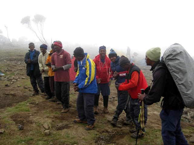
Our guides and porters, welcoming us to camp with a song. Hiking mountains is WAY easier with their help

Sarah and Goodluck

Though everyone who sets out to climb Mt. Kilimanjaro ultimately wants to get to the top, I’m pleased to report that the 4 days of hiking leading up to summit day are more-than-incredible in their own right: Walking through lush rainforests, seeing silhouette views of nearby Mt. Meru at sunset, camping on cliff edges overlooking spectacular valleys, walking through clouds and catching rewarding glimpses of Kili all along the way. The hiking alone is world class and THEN you get the opportunity to bag a peak.
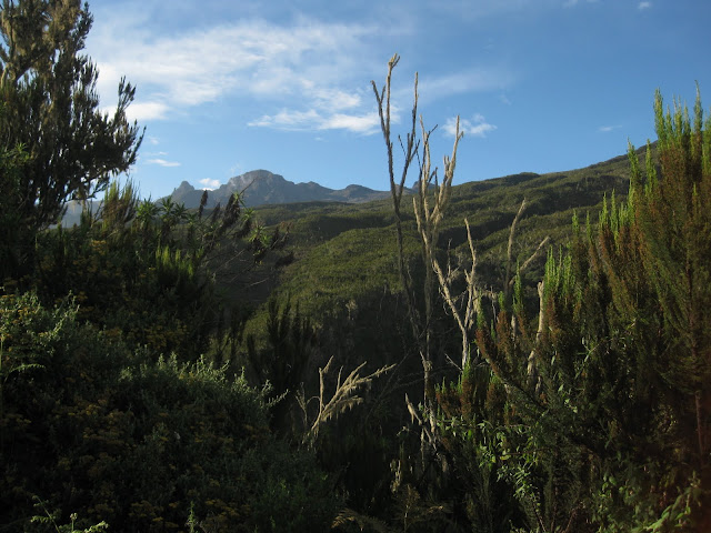
Amazing views along the trek up
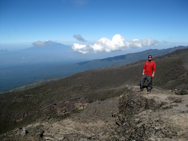
Nearby Mt. Meru in the background
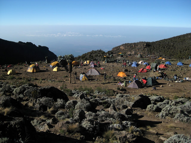
Awesome views from camp
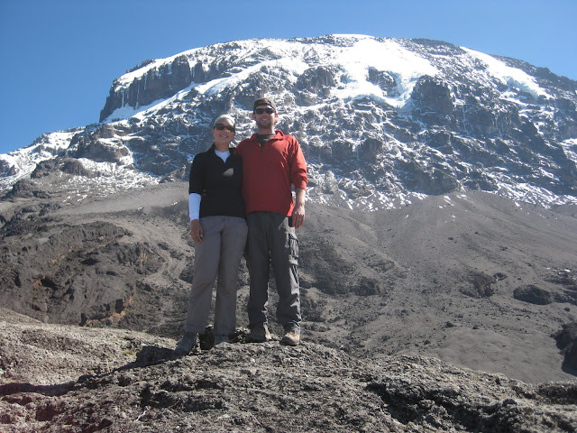
Still a ways to the top

Sunset above the clouds

Our guide was experienced and good. The motto on Kili is ‘pole pole’ (pronounced po-lay po-lay) – which simply means slowly slowly in Kiswahili. You walk slower than you want to (in fact, slower than we’ve ever walked before), but it keeps you from ascending too quickly and it allows you to keep a steady pace with minimal stopping. We’d walk about 6 or 7 hours a day with the maximum we went in one day being 12-13 km (~8 miles). We were both feeling really good, with no negative effects from the altitude – we were ready to conquer this beast.

Our 4th day of walking got us to Barafu camp (elevation 15,088 ft) around 3pm. Our job was to rest, eat an early dinner, and try to sleep as we’d be getting up at 11pm for our summit attempt. When we left camp around midnight, we were sore, we were tired (we had barely slept) and we were cold. Summit day had begun.


Copyright © 1996-2010 Oh, the Places We'll Go. All rights reserved.
iDream theme by Templates Next | Powered by WordPress